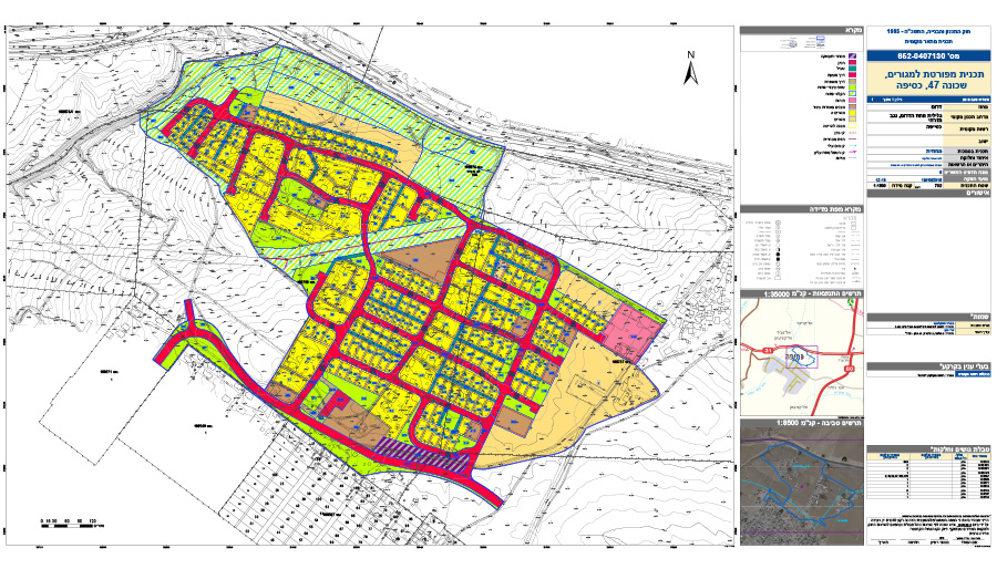
A detailed master plan including regulation of existing settlements, in an area designated as a suburban settlement area by Regional Master Plan 4/14/23. Most of the plan lies outside Kseifeh local council’s jurisdictional area; however this is an area which the local council wishes to include in its future jurisdiction. The plan proposes regulating the current residential areas within its boundaries, by defining these existing settlement areas as residential compounds. The plan also proposes additional residential lots in areas where there are no residents yet. The plan proposes a redesign of the current layout of designated agricultural land, proposing instead to change these lands to land for the use of the residents and land reserves for future development. The plan aligns with the principles of the Kseifeh outline plan with regard to infrastructure, land uses and allocation of public use land. The planning included a participatory process with residents living in the relevant area, and decisions on issues such as regulation of existing settlement, defining areas for densification and for future development and defining public spaces and roads and infrastructure networks were made with the consent of residents and suited to their needs
Kseifeh, Neighborhood 47- detailed residential plan
Project Initiation: 2015
Location: Neighborhood 47, west of Beersheba River, south of Route 31 and north of the existing town of Kseifeh
Project Area: 282.5 dunam
Status: Approved
Program: A residential neighborhood of approximately 750 units, public buildings and institutions, open spaces, agricultural land and a tourism site
Planning Team: Ari Cohen, Yaara Rosner-Manor, Ella Zilberfarb, Amir Elisha
 תשריט שימושי קרקע
A detailed master plan including regulation of existing settlements, in an area designated as a suburban settlement area by Regional Master Plan 4/14/23. Most of the plan lies outside Kseifeh local council’s jurisdictional area; however this is an area which the local council wishes to include in its future jurisdiction. The plan proposes regulating the current residential areas within its boundaries, by defining these existing settlement areas as residential compounds. The plan also proposes additional residential lots in areas where there are no residents yet. The plan proposes a redesign of the current layout of designated agricultural land, proposing instead to change these lands to land for the use of the residents and land reserves for future development. The plan aligns with the principles of the Kseifeh outline plan with regard to infrastructure, land uses and allocation of public use land. The planning included a participatory process with residents living in the relevant area, and decisions on issues such as regulation of existing settlement, defining areas for densification and for future development and defining public spaces and roads and infrastructure networks were made with the consent of residents and suited to their needs